
Find Middletown Streets by Address
A Middletown street directory works best as a chain of records, not as a list of everyone on a road. Start with the full physical address, including any directional word, fraction, and unit when it is needed to distinguish the property. The Orange County GIS locator accepts an address, city, state, and ZIP, and can return a candidate even when the address is incomplete. Confirm the municipality and parcel identifier before moving on. An assessed owner can be an estate, trust, or organization, and an owner mailing address can be somewhere else. That distinction keeps a Middletown street search tied to what each record actually establishes.
- Enter the address in the GIS locator, then record the selected parcel, municipality, and SBL or tax-map identifier. Keep the source spelling of the street.
- Use Orange County Parcel Information to compare the address with the assessment report and the owner name printed for that roll year.
- Follow the deed book and page or instrument lead through the Orange County Clerk. Treat grantor and grantee as parties to a recorded transfer, not as a statement of occupancy.
- For a current registration or poll-site question, use the person-specific NYS VoterLookUp only as its form permits. The live tool is not a street-wide resident list.
- For a dated household or business lead, ask Thrall to check the appropriate directory volume or newspaper reel. Preserve the year and page with the result.
That order keeps the Middletown address trail focused on a map point, parcel, recorded instrument, and dated historical context. A name alone should not be carried from one layer to the next without a matching address, date, municipality, or parcel field.
Middletown Parcel Search Fields
Orange County separates its property-data report from the map viewer, which is useful when a Middletown address produces several similar street names. The county advertises owner name, address, tax map number, and municipality as parcel-search dimensions. Select the City of Middletown when that option fits, then compare the report with GIS. The Middletown City Assessor is a separate office that handles assessments, exemptions, transfers, subdivisions, and lot-line work. Its address-change form also shows why a situs address and an owner mailing address must never be silently treated as the same field.
| Tool | Search fields | Result or next step | Limit |
|---|---|---|---|
| County Parcel Information | Owner name, address, tax map number, municipality | Parcel report, assessment, tax-map, photo, and comparable information | Assessed owner is not necessarily an occupant |
| GIS Parcel Search | Owner name, address, parcel ID, partial strings, and municipality or map area | Result table, map, Zoom, Buffer, and layers | Map lines are not a survey or title decision |
| GIS address locator | Address, city, state, ZIP, including incomplete address | Candidate match and map point | Postal city can differ from tax municipality |
| City Assessor form | Section, block, lot, property location, owner, old and new mailing address | Shows distinct situs and mailing fields | Administrative form, not a resident roster |
For this Middletown property search, use the SBL or tax-map number as the bridge field. It is more stable than a shortened street label and makes it easier to compare the GIS point, the assessment roll, and a deed reference without guessing.
Middletown GIS Street Matching
The county GIS is the practical map layer for a Middletown address search. Parcel Search accepts owner name, address, or parcel ID and supports partial strings. A researcher can limit a search to all municipalities, a selected municipality, or the visible map area. After choosing a result, Zoom places the parcel in its street setting and Buffer can show nearby tax parcels inside a chosen distance. Buffer results are adjacent parcels, not a personal-neighbor list. A street may also hold a vacant lot, apartment building, public facility, business, or a parcel with a mailing address outside the city.
The Orange County GIS address-locator help illustrates the county's address, city, state, and ZIP search route.
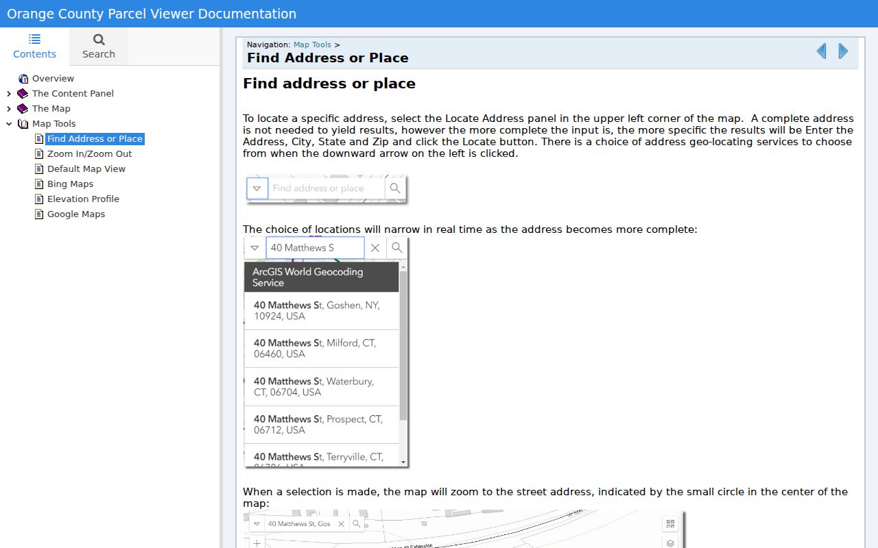
Use the returned map point as a starting location, then verify its municipality and parcel data before treating the match as a Middletown address.
GIS also supplies an important correction for same-name streets. If a result crosses a municipal edge or returns an unexpected postal city, compare the tax jurisdiction rather than assuming that the label “Middletown” means the incorporated city.
Middletown Address Records Compared
No single Middletown street record proves every part of an address history. The assessment roll identifies an owner and parcel for a stated roll year. GIS links that parcel to a map polygon. The County Clerk supplies the recorded instrument and the Thrall collection may supply a dated person or business association. City maps add ward, zoning, or official-map context. Keeping those sources separate prevents a street directory result from turning an old listing, a transfer party, or a mailing address into an unsupported claim about who is present now.
| Address-keyed record | Custodian | What it can establish | Access route |
|---|---|---|---|
| Assessment roll or parcel report | Middletown City Assessor and county property system | Assessed owner, situs, mailing field, SBL, class, assessment, and deed bridge | Published roll or county portal |
| GIS parcel layer | Orange County GIS | Address point, parcel polygon, municipality, map layers, and adjacent-parcel context | Public map viewer |
| Recorded deed | Orange County Clerk | Grantor, grantee, recording date, legal description, book/page, or instrument number | SearchIQS or Record Room |
| Ward-by-street map | City of Middletown | Political and planning geography for a Middletown street | City map pages |
| Historical directory | Thrall Local History | Dated Middletown name, street, occupation, or business context | Microfilm or digitized page |
Note: A tax roll, map pin, or deed party is a record-specific fact, not a substitute for direct proof of present occupancy.
Middletown Deed Chains by Street
A deed chain can extend a Middletown street directory search backward, but the parcel comes first. Record the current situs, SBL, legal description lead, and book/page or instrument number. Then consult the Orange County Clerk's online-record instructions and its SearchIQS route. SearchIQS requires an account or subscription at the inspected entry point. The county's Record Room offers public computers, plain and certified copies, and help with historical or fragile material. Take the exact record type and index number when requesting a copy.
Coverage needs care. County material describes land records from January 1, 1978 to the present while prior scanning continues; historical grantor/grantee books cover 1910 through 1977, and the date sheet identifies deed images from December 24, 1947 through January 5, 1978. SearchIQS availability information separately describes land data from December 31, 1953 forward with back scanning. Those statements are not interchangeable. Ask the Record Room which layer is available for the chosen date, whether it is an index or image, and what copy service applies.
Middletown Street Directory History
Historical work uses a different kind of Middletown street directory. The city was known as South Middletown from 1829 to 1849, and the old Minisink Road corresponds with modern East and West Main Street. Those names can explain why a directory, newspaper, or map appears not to match a present-day search. The city historical chronology also dates the 1851 Whig Press run and the 1843 railroad arrival, which can add a published date to an address lead. They do not prove a current household.
Thrall Local History confirms city-directory holdings from 1871 through 1984 and a digitized 1857-1858 Middletown directory. No separate official reverse or criss-cross run has been verified. Ask staff whether the specific volume has a street section before relying on it. When a past household matters, the Middletown city directories collection provides the fuller historical-source route. Copy the directory year, title, publisher if shown, and page so a later result can be checked against the alphabetic section or adjacent years.
When the source leaves a conflict, record it rather than smoothing it away. A street-only hit is a block lead, not an exact property match. A different number may reflect a business entrance, a multi-unit building, an old address style, or a nearby municipality. Compare the legal description, map, and directory date before connecting the entries. The research found no official citywide renumbering event, so a changed number must be verified from the actual source trail.
Middletown Street Wards and ZIPs
A Middletown street can sit within several geographic systems at once. Middletown city map pages publish street, ward-by-street, ward, and zoning maps. Their purpose is municipal geography, so a ward result can help distinguish a street segment but does not identify a household. The City Official Map is dated April 9, 1956, and the city points later changes to Planning Board and clerk filings. For a changed or uncertain number, compare that material with a directory, assessor record, postal source, and the deed's legal description.
Postal labels need the same caution. The research confirms 10940 as the core Middletown ZIP through the local post-office listing, while 10941 is associated in county material with Middletown-related or Town of Middletown addresses. Neither label alone settles city limits. Parcel municipality and ward are stronger checks for a city-specific street record.
Middletown Street Record Gaps
Some useful address records require a direct request. The City Clerk handles municipal records, permits, licenses, and local vital records, while Public Works, Building, and Code Enforcement handle construction and inspection activity. A public searchable Middletown building-permit or code-case database was not located in the research. For one address, use the city department or Middletown FOIL with a record description, address, date range, and permit number if known. The city advertises electronic records as free and physical copies at $0.25 per page.
This is a useful insider check: a public permit is an agency transaction, not a declaration of who lived at the address. The same applies to a City Clerk license or a municipal meeting record. Request the narrow record needed, retain the agency and date, and do not expand an address lead into a household profile.
Middletown Address Terms Defined
Middletown records use fields that look similar but answer different questions. Label them as they appear. That small habit helps when an old street number, a PO box, or a deed description does not line up with the map.
- Parcel
- A mapped piece of land tracked by the county, usually with an SBL or tax-map identifier.
- Situs address
- The physical property location used by an assessment record, separate from an owner's mailing field.
- Plat or tax map
- A mapped record that identifies parcel layout and reference numbers; it is not a legal survey by itself.
- Criss-cross directory
- A directory section arranged by street and number rather than surname, if a particular historical volume contains one.
Use the exact source label in notes. A “mailing address” should stay a mailing address, and an historical directory entry should stay tied to its printed year.
Protecting Middletown Street Privacy
A Middletown street directory cannot responsibly produce a unit-by-unit household list. Do not publish private phone numbers, children’s details, protected court locations, or an address belonging to an Address Confidentiality Program participant. New York's ACP provides a substitute mailing address for eligible people, and confidential voter registration is kept outside ordinary public voter materials. An old address should be labeled with its date, and a mailing address should not be recast as a residence.
Lawful use. Use Middletown address records for personal, lawful research and source verification. Never use record details to stalk, harass, intimidate, or expose a protected person.
Good address research stops at the custodian's boundary. When the records do not support an occupancy conclusion, preserve the parcel, date, and access route instead of filling the gap with an inference.